
Attraction in Khao Lak
Beyond Phang Nga town
Phang Nga’s abundant and virgin forests provide the excellent home to wild animal as well as various species of vegetations. As a result, many national parks were established in the province proving obviously the fertility of its natural resources. In each Park, there are many natural attractions waiting for your discovery.
 Khao Lamphi-Hat Thai Muang National Park was declared a national park on 14 April 1986, composed of the range of granite hills covered with densely rain tropical forests and the beach bordering the Andaman Sea. On the east side of the beach offers the dazzling sand while on the west side is fringed with the fertile mangrove forest, and there located the national Park Office.
The interesting sites in the Park are:
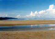
- Hat Thai Muang Beach was formerly a tin mine when the mining trade was once in bloom around the region. Now, mining ceased, the only trace indicating its previous presence is just its name (Muang means mine). The beach itself is clean and parallels the highway for more than 13 kilometers. Its water is crystal clear, making it a good place for swimming. Each year during the months of November and February, the mother sea turtles come to lay their eggs on this beach, and local inhabitants usually come to seeing the turtles on moonlit nights. In March, the annual Turtle Releasing Festival is held for the numerous baby turtles that have previously been hatched will see their first days during this time of the year.
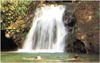
 Tone Prai Waterfall is a huge fall, originating in Ton Yan Sai Mountain. The areas are surrounded by the lavishly green forest.
- Lamphi waterfall is a medium-sized fall, originating in the mountain range of Lamphi. There is a big bowl which is abundant of water all year round. The fall is often visited during the rain season when the fall is at its most beautiful.
- Conservation Center of the Princess Chulabhorn Undersea Park Project is a good place to study about the undersea environment and its resources. There are rooms displaying the work of the Chulabhorn Research Institute’s royal chairman and the exhibition hall featuring Chulabhorn Projects origins, the importance of undersea resources and environments, new ideas in undersea eco-tourism, and artworks focusing on undersea world themes. The Center is located at Tap Lamu Naval Base.
 Tone Prai Waterfall is a huge fall, originating in Ton Yan Sai Mountain. The areas are surrounded by the lavishly green forest.
To get to the Park, from Phang Nga town, follow the Phang Nga-Thai Muang Route for about 56 kilometer. Then turn left at the junction of Thai Muang Market and go for another 6 kilometers, you will get to the National Park’s Office. If you are heading from Bangkok, take Petchkasem Road which passes Takua Pa district, then take the Takua Pa-Thai Muang Route for about 66 kilometers and you will reach the junction of Thai Munag market.
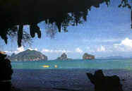
Khao Lak-Laem Ru National Park is one of many national parks in Phang Nga. The Park sprawls over the total area of 125 square meters along the west shore line. It includes parts of Thai Kapong, Takua Pa, and Phang Nga town districts, located about 33 kilometers south of Takua Pa on Route 4. The Park offers a heap of sightseeing opportunities for nature lovers. Khao Lak’s outstanding beauty is its natural surrounding which consists of a variety of landscapes; one side, it is fringed by the aquamarine Andaman Sea which offers the dazzling beach and sea as well as abundant coral beds; on the other side is shrouded by the tapestry of lavishly verdant jungle, an excellent habitat to the rare species of animals and plants. Here, you can absorb the stunning nature in ecstasy amidst the peaceful and tranquil ambiance away from the frazzle and dazzle of more populated spots nearby. Alternatively, you can take an adventure in the dense jungle; elephant riding, trekking on the nature trail or canoeing along the ridge of mangrove forest are all available according to your favors.
The surrounding areas in the Park are composed of several natural attractions:-
- Khao Lak Beach has been known as the new relaxing place just a few years ago due to its exceptional nature and tranquility, making Khao Lak rapidly comes into popularity as the secluded paradise among both Thai and foreigners. It is situated 32 kilometers away from Takua-Pa District or about 2 hours from Phuket International Airport, lying on the west side of the National Park. Khao Lak beach is well-known for its large sandy beach with a picturesque composition of boulders and rocks, fringed by the shady casuarinas and palm trees. At the crepuscular time, the beach offers the pristine and tranquil atmosphere, offering the spell-binding sun set. Offshore, some beautiful coral gardens which are perfect for diving and snorkeling are also provided. The coral beds can be reached by a hired long-tail boat, taking about 45 minutes form the beach.

- Tone Chong Fah waterfall lies about 5 kilometers north from Khao Lak along the main coast highway from Phuket up to Takua Pa. The fall itself originates in Klong Bangniang, formed by the 5-tier-cliff with waters flowing through all year round. Backed up by the verdant forest, the fall provides the pleasant atmosphere for relaxation. The dense forest is also a home to some endangered animals such as tapirs and hornbills. It can be easily accessed by rental jeep or motorcycle.
- Laemru waterfall is medium in size with five tiers, abundant with water all year round. The surrounding is teemed with shady trees, providing a relaxing atmosphere.
You will be able to go to Khao Lak-Laem Ru National Park by taking a bus from Bangkok to Phang-Nga at The Southern Bus Terminal, leaving daily. The trip takes about 12 hours. Also, you can get there from Phuket by a regular bus for 2 hours. The most convenient is going by plane; it takes only one hour from Bangkok to Phuket, and there are airport-taxi going directly to Khao Lak.
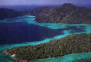 Surin Island National Park is a group of five islands, standing about 70 kilometers offshore in the Andaman Sea near the marine boundary between Thai and Myanmar. It is located within the area of Kuraburi district, declared to be a national park on 9 July 1981. The Island is visited for its beautiful coral beds in both shallow and deep waters. For the best shallow-water-corals is on Khai Island or Torinla Island and Klang Isand or Pajumba Island, and the excellent deep-water-one is on the undersea boulder heap submerging around 10 kilometers southeast of Surin Island. This point is one of the most abundant and unspoiled coral reefs with multicolored marine lives; you would also have a chance to see the whale shark roaming around. Due to its remoteness from the mainland, the Park is beautifully virgin; you are then offered the real pristine atmosphere.
The island’s climate is dominated by the tropical monsoon like its mainland; the heavy rain comes in May until October, causing the difficulty to get there. The best time to visit the island is when the monsoon ends-that is from November to April.
The five islands which make up the National Park are: Surin Neua, Surin Tai, Ri, Khai, and Klang Islands. The two large islands are Surin Neua and Surin Tai (which mean, respectively north and south); they are connected to one another with a water groove demarcating their border. Surin Neua Island is the siege of the Park’s Headquarter and several chartered boats for traveling to other islands. These two large islands possess ten bays, each of which offers beach and water in their characteristic beauty. The best known are:-
Surin Neua Island
- Mae Yai is the largest bay, located north of the Island. It is visited for its excellent coral garden and its calm sea as well as gentle breezes.
- Ao Luk lies on the southeast shore. Luk, its name means deep, it is so deep that the waters turn into dark green. The bay is graced, however, by the excellent shallow-water coral beds rich in various marine lives.
- Ao Chong Khad lies on the southern part, offering the white dazzling beach and clear water good for swimming. Underwater, various kinds of multicolored fish often come to greet snorkellers lively.
- Ao Sai En stretches on the east side. On the bay, there is a community of sea gypsy people called Morgan who still practice their own primitive lifestyle and original culture; they live on the boats served as their houses and still believe in spirits.
- Ao Jak stands in the north, offering finest white sand and magnificent coral beds, making it the excellent site for swimming and snorkeling.
- Ao Mai Ngam lies in the west of the Island, next to the Headquarter of the Park. This is a big bay fringed with the long bed of beautiful coral. Around the area, there is a nature trail which passes through a dense jungle paralleling the beach. On the trail, you can see the scarce flora and fauna indigenous to the area; it requires about 1 hour finishing the trail.
Surin Tai Island
- Ao Bon lies east of Surin Tai Island. There is another group of sea gypsy people living here.
- Ao Tao is on the east side, offering the abundant coral reefs which are a good habitat of many sea turtles. This is another good site for snorkeling.
- Ao Pak Gad lies in the south, offering the site of both shallow-water and deep-water coral reefs.
- Ao Suthep is visited for its flourishing coral reefs which are good for snorkeling.
The other islands
- Koh Pajumba or Klang Island is located north of Surin Tai Island, providing a long white stretch of sand. The beach is fringed by the magnificent coral beds with various kinds of marine lives. The ecology around here is very abundant that you can see many rare species of marine creatures such as lobsters and sea turtles.
- Koh Torinla or Khai Island lies in the south of Surin Tai Island. On the east side of the island, there is a long stretch of coral reefs which is still in excellent condition, rich in colorful corals and fish, making it a good site for diving.
There are several piers from where visitors can to get to Surin Island National Park.
From Kuraburi Pier, Ban Hin Lad: Ban Hin Lad is located at kilometer 110 on the Ranong-Takua Pa Highway. Then fork from the main road at Ban Hin Lad School, and go onward to the pier about 1 kilometer. The boat trip to the National Park takes about 4-5 hours. A reservation for a boat trip in advance from the National Park Office is recommended. (Tel. 076-491477-8, 595068)
From Tap Lamu Pier in Thai Muang district: Tap Lamu Pier can be reached by different ways. The first way is going form Bangkok; take a bus Bangkok-Ranong or Bangkok-Suratthani. When reaching the intersection of Lam Kaen in Thai Munag district, drop off there. Then take a hired motorcycle to the pier. Secondly, you can go to the pier from Phang Nga town; there are local buses Phang Nga-Tap Lamu leaving from the Provincial Bus Terminal. Alternatively, you can go to Thai Muang district from where you can take songtaews (local minibuses) to the pier. The boat trip form Tap Lamu Pier takes about 4 hours.
However, the transportation from these two piers is good for a tour group. For the individual travelers, the best way is to join a dive trip out of Phuket that includes Surin Island on the itinerary except that you would like to take a kind of adventure by hitching a ride or paying a reasonable fraction of the rental cost on a boat chartered by a group because there is no regular boat service for travelers to the Island.
Similan Island National Marine Park is composed of nine islands and covers an area of about 130 square kilometers. Situated 50 kilometers off the coast of Phang Nga amidst the Andaman Sea, Similan Islands were declared a national park on 1 September 1982. Similan, its name is corrupted from the Malay word sembilan meaning a group of nine islands. The largest island among them is Similan Island also called Koh Pad or Eight Island. The nine petite islands line in the north to south direction, namely, HuYong, Payang Payan, Miang, Payu, Bon, Similan, Ba Ngu 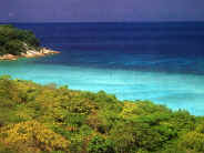 Islands- each with the number as a nickname. Each island offers its idyllically characteristic beauty, and most of them are uninhabited. The Park’s headquarter is located on Miang Island which has a plenty of fresh water provision.
The Park is praised for its incomparable and breathtaking underwater scenery, allowing it one of the ten most popular diving destinations in the world. With its magnificent extensive coral gardens in excellent condition together with the wondrous underwater landscape which offers a remarkable dive, Similan Island deserves all notability of both skin-diving and deep-water diving. Additionally, Similan is regarded as one of the most fertile marine resources in Thailand due to its considerable variety of species of fish, crustaceans, and other marine lives. Apart from the great beauty of underwater world, Similan Archipelago also offers the unspoiled nature of verdant greenery which is home to thirty-two species of birds including resident birds like Brahminy kite and white-breasted waterhen as well as migratory species of the pintail snipe, gray wagtail, cattle egret, watercock, and roseate tern. The spectacular beauty of both in land and in water can be found on the nine islands, some of the famous ones include:-
- Similan Island (Koh Pad-8) is the largest among the others, possessing the striking granite outcrop in shape of horseshoes. Lying in the north, Similan Island encompasses a long curving bay with powdery white-sand beaches and splendid underwater scenery. The water is brightly aquamarine; underneath, the coral reefs and colorful fish are abounding; multicolored sea fans and plume warms move gently in blue water, creating the impressive sight. North of the island, there cluster boulders and rocks in different strange shapes such as a soldier’s boot and a sail boat. From this point, you get a picturesque panorama far ahead until it melt with the horizon.
- Miang Island (Koh See-4) is the second largest island of the archipelago; it is actually two islands connecting with each other. Headquarter of the Similan National Marine Park and guesthouses are located on this island. Miang Island is prominent for its dazzling beaches and wonderful coral gardens which are perfect for snorkeling. The best location is at the channel between Miang Island and Payu Island. In addition, the rare species of crab and bird can also be found here. The so-called Poo Kai (Cock crab) is one among the other; it is a curious animal for its crying sounds like a cockcrow; also the beautiful wild pigeon with its colorful feathers which is one of the endangered species can be often seen on the beach.
- Ba Ngu Island (Koh Jed-7) is a rocky island with a strange feature of a skull-shape; it is thus also known as Hua Kalok Island. The island is distinguished for its incredibly sparkling scenery underwater with colorful fish, seaweed and coral reefs. The whale sharks and rays are often seen at this excellent diving point.
- Hu Yong Island (Koh Neung-1) possesses the longest stretch of white sand among the others of the archipelago. During the months of November and February, there are several sea turtles coming to lay their eggs on the beach and leaving their trace as if there were a hundred of centipedes creeping around.
Around the area of the Park, there are many other interesting dive sites of which their beauty is second to none, but different only in landscape and location, for example, Koh Tachai, Koh Bon, Christmas Point, and Fantasy Point.
Transportation to Similan National Marine Park: There are boats leaving from different piers to go for Similan Archipelago.
- Tap Lamu Pier: It is located in Thai Muang district, 70 kilometers away from Phang Nga town along the Phang Nga -Takua Pa Route. This is the closest pier to the National Park, approximately 40 kilometers. The boat trip takes about 3-4 hours.
- Kuraburi Pier: The Pier is situated in Kuraburi district, 70 kilometers from Similan Archipelago; the journey takes 3 hours.
- Patong Beach Pier: It is in Phuket province, located about 70 kilometers away from the Park. The boat trip takes about 4 hours.
Basic accommodations are available at the National Park Office on Miang Island and can be reserved by contacting the Similan National Marine Park Office in Thai Muang district. The best period to visit the Park is from December through April. March is the best month, when the winds are lowest and the water is clearest. From May through November, it is the monsoonal seasons which cause difficulties for transportation to the islands, the Islands are then closed to all visitors in May.
Phra Thong Island is located in Kuraburi district. It is a large island standing amidst the Andaman Sea, renowned for its beautiful beach and fertile rain forest which is a home to various kinds of wild animals as well as secluded atmosphere. The Island is also inhabited by the fishery villagers. To get to the Island, take a boat at Kuraburi Pier; the boat trip takes about 1 hour. Private accommodations are available on the Island.
This article is written and copyrighted by
Royal Exclusive Travel Co. Ltd.
Royal Exclusive Travel Co. Ltd.
|
|